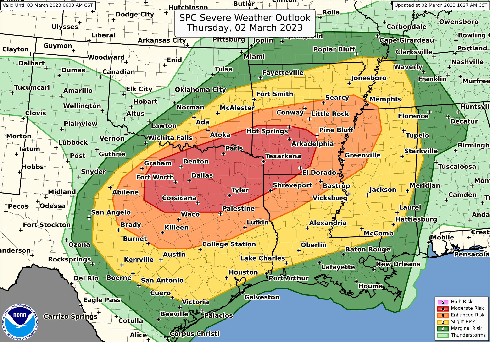
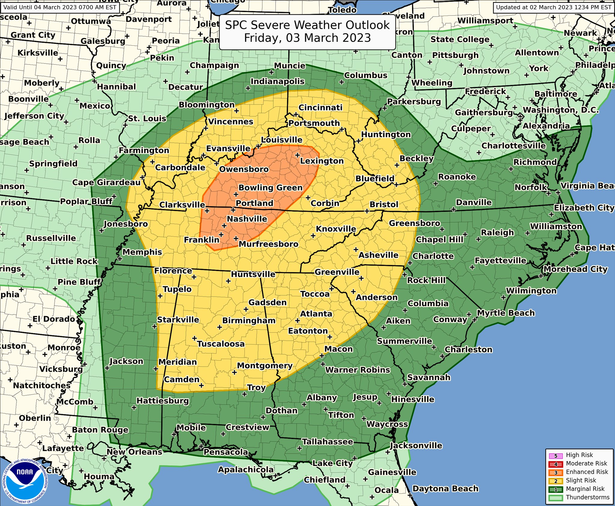
The South will see two more days of active Severe Weather threats. Today, Thursday, March 2, 2023, there is a very large area in the Severe weather outlook, with the possibility of Tornadoes, Hail, and Damaging Winds. This includes areas from Texas to West Tennessee and Mississippi. Some STRONG TORNADOES will be possible across the outlook areas today. On Friday, March 3, 2023, there will be another threat of Severe Weather for a majority of the State of Alabama. This is be mainly a morning event, most likely before 12 noon, from what the current timing looks like. Damaging Winds and a few Tornadoes will be possible on Friday.
Here’s the latest from The Storm Prediction Center:
“It’s going to be busy weather-wise today and tomorrow! For today, a Moderate risk (level 4/5) for severe weather stretches from north-central TX (including the DFW metro area) to southwest AR. Primary hazards including large hail, damaging winds, and tornadoes.
The severe weather threat will shift east tomorrow with an Enhanced risk (level 3/5) over middle Tennessee (including the Nashville area) and central Kentucky, though severe weather is possible across much of the southeastern U.S. The main hazards will be damaging straight line winds and tornadoes.
For the latest updates regarding the severe weather threat go to:
Full Day 1 Convective Outlook Text:
Day 1 Convective Outlook
   NWS Storm Prediction Center Norman OK
   1027 AM CST Thu Mar 02 2023

   Valid 021630Z - 031200Z

   ...THERE IS A MODERATE RISK OF SEVERE THUNDERSTORMS THIS AFTERNOON
   INTO TONIGHT FOR NORTH CENTRAL TX INTO THE ARKLATEX...

   ...SUMMARY...
   Severe thunderstorms with very large hail to the size of baseballs
   or larger, significant thunderstorm gusts to 75 mph, and a couple of
   strong tornadoes are likely from north Texas into the ArkLaTex this
   afternoon through tonight.

   ...Synopsis...
   A compact midlevel shortwave trough will move over southwest TX
   later this afternoon, and then eject northeastward toward AR by the
   end of the period.  Substantial surface cyclogenesis is expected in
   advance of the ejecting midlevel trough and 110+ kt midlevel jet
   streak, from north central TX later this afternoon to
   western/northern AR overnight.  A reservoir of 65-72 F
   boundary-layer dewpoints is present from central/east TX into LA/MS
   as of late morning, and continued northward advection of moisture is
   expected through this afternoon into tonight.  The north edge of the
   surface warm sector is not expected to move much to the north
   through this evening, with a front remaining quasi-stationary from
   north TX to southern AR.  A remnant outflow boundary will tend to
   slowly become more diffuse through this afternoon across the DFW
   area.

   The approach of the midlevel trough, mass response to cyclogenesis,
   and surface heating in cloud breaks all suggest that thunderstorm
   development is probable by early-mid afternoon across central TX and
   western north TX, with storms spreading east-northeastward into the
   DFW area, northeast TX and extreme southeast OK through late
   evening.  The initial storms will likely be clusters of supercells
   capable of producing very large hail and swaths of damaging winds as
   storms grow upscale into a line along the surging cold front from
   central into northeast TX this evening (some of which could produce
   significant gusts.  Forecast hodographs also suggest some potential
   for tornadoes, including a strong tornado or two, though the most
   favorable wind profiles will correspond to tonight when storm mode
   will likely be more linear.  The compact nature of the jet structure
   suggests that the stronger/deeper forcing for ascent will travel
   along the path of cyclogenesis, from far northeast TX/southeast OK
   into AR tonight.  South of this area, ascent will be weaker and
   relatively warm temperature profiles aloft suggest that storm
   development is more questionable with southward and eastward extent
   across LA/MS overnight.