NORTH ALABAMA — Residents across North Alabama will need to stay weather aware Wednesday afternoon through Wednesday night as another round of strong to severe thunderstorms is expected to move across the region.
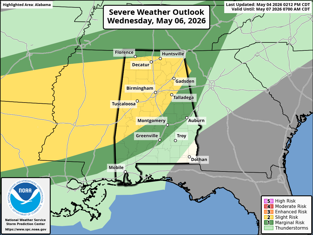
The Storm Prediction Center has placed areas from eastern Texas into Alabama under a Slight Risk, or Level 2 out of 5, for severe thunderstorms on Wednesday. Forecasters say scattered strong to severe storms are expected across portions of the lower Mississippi and Tennessee Valleys, with damaging winds, large hail, and a couple of tornadoes possible.
For North Alabama, the greatest concern appears to be from late Wednesday afternoon into Wednesday evening, especially across northwest, north-central, and northeast Alabama. This includes areas such as Florence, Decatur, Huntsville, Cullman, Scottsboro, Albertville, Fort Payne, Rainsville, Gadsden, and surrounding communities.
The National Weather Service in Huntsville says there is a low to medium risk of strong to severe storms Wednesday afternoon and Wednesday night, with damaging winds as the main threat. The Huntsville office also notes lower confidence in hail and tornado potential, along with a low risk of heavy rain and localized flooding.
The setup will feature a cold front moving toward Alabama, with warm and humid air in place ahead of it. Dew points may climb into the upper 60s and lower 70s, giving storms enough instability to become strong if they develop during the afternoon and evening. The SPC notes that storms may initially develop as stronger individual cells or clusters before possibly merging into bowing lines, which would increase the damaging wind threat.
At this time, the main severe weather threat for North Alabama appears to be damaging straight-line winds, especially if storms organize into a line. Some storms may also produce large hail, particularly if they remain more isolated before merging together. The tornado threat does not appear to be the primary concern, but an isolated tornado cannot be ruled out, especially with any storm that can remain semi-discrete or rotate briefly.
Central Alabama will also have a risk of severe storms later Wednesday into early Thursday. The National Weather Service in Birmingham says a Level 1 to Level 2 risk is in place for a few severe storms, with threats including isolated brief tornadoes, damaging wind gusts, and heavy rain. The Birmingham office says much of the stormy weather across Central Alabama may occur during the night.
For the WVSM coverage area in Northeast Alabama, the most likely timing appears to be Wednesday evening into Wednesday night, though the exact timing may change depending on how storms evolve to the west. Areas west of I-65 may see storms earlier, while northeast Alabama could see the main activity later in the evening.
Forecasters caution that the severity of the storms will depend on how much the atmosphere can recover after any early-day clouds or showers. If sunshine and heating are more widespread during the day, the severe threat could increase. If rain and clouds linger longer, the threat may be somewhat reduced.
Residents are encouraged to have multiple ways to receive weather warnings, especially since part of the threat may continue after dark. Make sure phones are charged, weather alerts are turned on, and weather radios are ready in case warnings are issued Wednesday afternoon or Wednesday night.