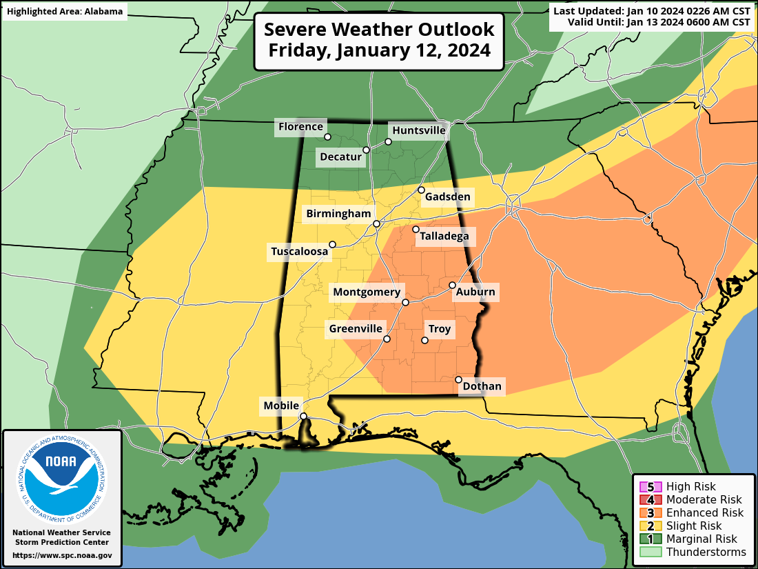
As of the latest weather forecasts, an enhanced risk of severe thunderstorms is anticipated on Friday afternoon into Friday evening across parts of East Central and Southeast Alabama, much of Central Georgia, and South Carolina into Southern North Carolina. Surrounded by a Slight Risk Area that extends from Mississippi to the Carolinas.
Summary: Severe weather conditions are expected to impact the Southeast on Friday, with the potential for high winds and a few Strong Tornadoes. The risk is most pronounced in areas spanning East Central and Southeast Alabama, much of Central Georgia, and extending into South Carolina and Southern North Carolina. There will be the risk of widespread Damaging Winds and the possiblity of several Tornadoes across the outlook area.
Discussion: Weather models indicate the development of a powerful cyclone across the Mississippi Valley through the Atlantic Seaboard on Friday. This cyclone is expected to rapidly intensify over the lower Ohio Valley, leading to the likelihood of severe thunderstorms in the Southeast.
Deep-layer wind fields are anticipated to strengthen, with southwesterly flow reaching speeds of 90-120+ knots at 500 mb. In the 850-700 mb layer, 50-90 knots of south to southwesterly flow will overspread the advancing warm sector inland. There is uncertainty regarding the extent of the unstable warm sector, with the potential for destabilization in certain areas.
Low-level moistening is expected over the north central/northeastern Gulf of Mexico, extending into the eastern Gulf through the southern Atlantic Coast states. The risk of severe thunderstorm development increases, with a corridor of stronger surface pressure falls developing from Alabama through the Carolinas on Friday afternoon into Friday evening.
While storm mode remains uncertain, concerns persist regarding the environment supporting discrete Supercell development, posing a risk for strong tornadoes. Additionally, the evolution of an organized cluster with very strong and damaging convective gusts is possible.
Residents in the affected areas are advised to stay informed about weather updates and follow any warnings issued by local authorities. Preparedness measures should be taken to ensure the safety of individuals and property in the face of potential severe weather conditions.