The following article is published by the Alabama Emergency Management Agency
By Jim Stefkovich, Meteorologist, Alabama Emergency Management Agency
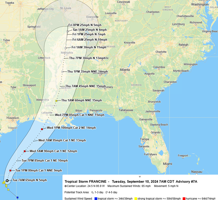
CLANTON – Tuesday, 7:30 am September 10, 2024
Hurricane Francine will make landfall on the Louisiana coast Wednesday afternoon or early evening as a Category 2 with sustained winds of 100 mph. The intensity will decrease rapidly after that but remain tropical storm strength until late Thursday morning when the center is forecast to be in Mississippi.
Looking at specific hazards:
Wind/Tornadoes
There remains a 10%-20% chance of sustained tropical storm-force-winds across Mobile and Baldwin counties and 5%-10% chance in far southwestern Alabama. The earliest arrival time would be Wednesday morning or afternoon. However, there could be wind gusts at or above 40 mph in rainbands Wednesday across the southern half of the state and statewide Wednesday night through Thursday.
Non-precipitation wind gusts of 25-35 mph will occur statewide from Wednesday evening through early Thursday evening and across the state’s northern half from Thursday evening through early Friday morning.

There is the threat of a few tornadoes across the southwestern sections of Alabama from early Wednesday morning through early Thursday, and across most of the state from Thursday morning into the evening hours.
These types of tornadoes typically develop very quickly in rainbands without much advance warning, move very fast, and can be rain-wrapped, making them hard to see. If a warning is issued for where you are, immediately get into a sturdy building on the lowest floor.


Rainfall/Flooding
Widespread 2-4 inches of rain is forecast for the western half of the state mainly from Wednesday morning through Friday morning, with locally higher amounts possible. This could produce some local flooding issues in urban areas, but the overall flooding threat from rain alone is small.
However, the combination of rain and wind near the coast will likely result in minor to moderate coastal flooding in low-lying areas, including Mobile Bay. Flooding of the Mobile Bay Causeway is likely during the Thursday morning commute and other low-lying regions such as Dauphin Island and Coden.
Direct link to the article: https://ema.alabama.gov/2024/09/10/francine-to-make-landfall-as-category-2-hurricane/