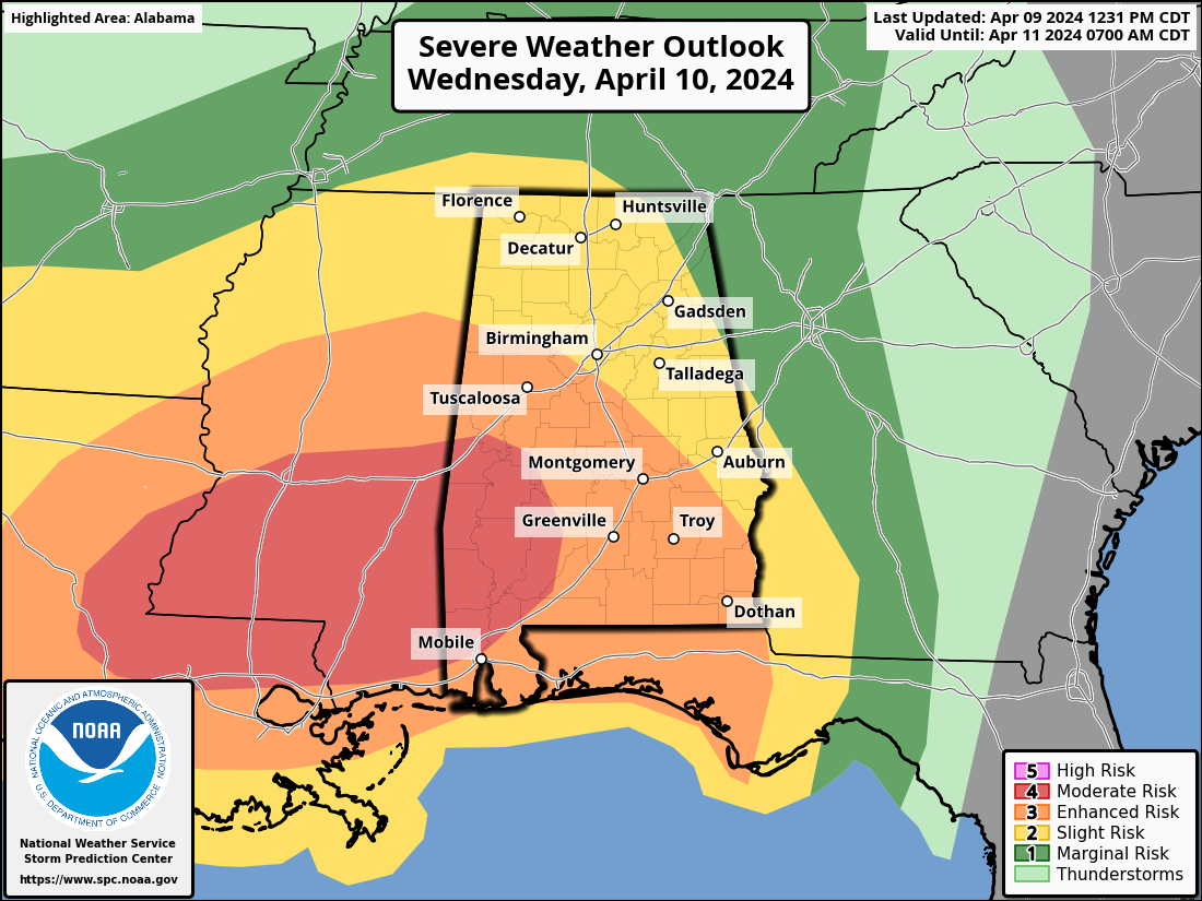
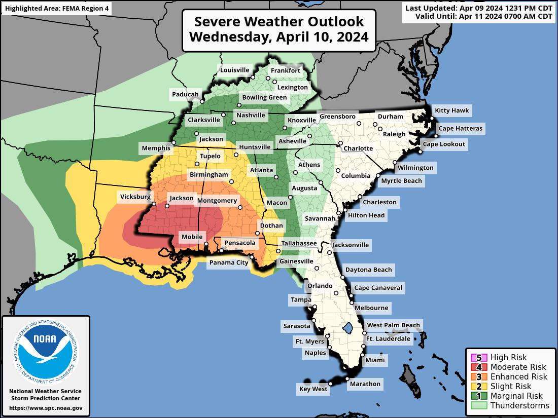
Widespread Severe Thunderstorms Forecast Across Central Gulf Coast States
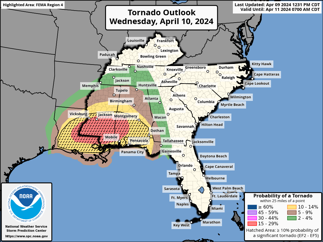
As Wednesday morning dawns, a looming threat of severe weather casts a shadow over parts of the central Gulf Coast States. The forecast warns of potentially severe thunderstorms, including the risk of several tornadoes, with some possibly reaching strong EF2+ intensities, alongside widespread damaging winds. The highest risk areas will be Central and Southern Mississippi and Alabama.
The meteorological synopsis paints a picture of atmospheric instability and dynamics primed for severe convective activity. An upper-level low, trekking eastward across northern Texas, is expected to transition into an open wave near the ArkLaTex by evening. Concurrently, mid-level southwesterly winds of 60-70 knots will intensify, alongside a southerly low-level jet reaching speeds of 60-70 knots, contributing to enhanced shear and moisture advection.
At the surface, a low pressure system lingering near the Sabine Valley is anticipated to gradually shift eastward, traversing Mississippi and into Middle Tennessee by Thursday morning. Ahead of this system, a convectively charged front will stretch northeastward from the Sabine low, likely triggering widespread rain and storms, particularly in southeast Arkansas and northwest Mississippi.
Early Wednesday, storms are expected to be active across Louisiana, Arkansas, and expanding into Mississippi, fueled by rich low-level moisture and considerable atmospheric instability. Deep-layer shear will favor the development of long-lived severe storms, including damaging bows and supercells, with a heightened tornado risk east of the Mississippi River.
As the day progresses, the complexity of storm evolution may increase due to early-day storms, potentially leading to the development of supercells along existing outflow boundaries. Additionally, diurnal warming and moisture advection could further exacerbate the severe weather potential, particularly in areas experiencing warm advection precipitation.
During the overnight hours, storms are likely to consolidate along a cold front extending from the Gulf of Mexico into southern Alabama and the western Florida Panhandle. Despite potential stabilization effects from antecedent convection, favorable shear conditions persist, maintaining the threat of supercells and tornadoes. A wedge of air mass recovery ahead of the storm line may exacerbate the situation, with strong tornadoes possible given the high effective storm-relative helicity.
Residents across the affected regions are urged to stay informed and heed any warnings issued by local authorities as the severe weather unfolds. Precautionary measures should be taken to ensure personal safety and property protection in the face of these potentially hazardous conditions.