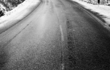
The National Weather Service is warning motorist to use extreme caution while traveling overnight tonight and into Tuesday morning. With the heavy amounts of snowfall that occurred on Sunday night, as that snow melts, it will leave areas of moisture on the roadways. Temperatures are forecast to drop into the low 20’s overnight tonight and this will help to freeze any water on roadways and creating black ice.
Black ice, sometimes called clear ice. It is a thin coating of glaze ice on a surface of roadways. The ice itself is not black, but visually transparent, allowing the often black road below to be seen through it.
Special Weather Statement
National Weather Service Huntsville AL
222 PM CST Mon Jan 3 2022
ALZ005>010-016-TNZ076-096-097-041200-
Limestone-Madison-Morgan-Marshall-Jackson-DeKalb-Cullman-Moore-Lincoln-Franklin TN-
Including the cities of Athens, Huntsville, Decatur, Albertville,
Boaz, Guntersville, Arab, Scottsboro, Fort Payne, Rainsville,
Cullman, Lynchburg, Fayetteville, Winchester, Sewanee, Decherd,
Estill Springs, and Cowan
222 PM CST Mon Jan 3 2022
…Black Ice Possible Tuesday Morning Along and East of Interstate 65…
Melting snow will refreeze this evening across the Tennessee
Valley, creating patches of black ice, especially on bridges and
overpasses Tuesday morning. This includes Limestone, Morgan,
Cullman, Marshall, Madison, Jackson, and Dekalb Counties in Alabama.
In Southern Middle Tennessee, this includes Lincoln, Franklin, and
Moore Counties.
Allow extra time to reach your destination Tuesday morning, and do
not assume that a well traveled roadway will be free of snow or ice.
Stay tuned to NOAA Weather Radio, or a favorite local media outlet,
for further statements or updates from the National Weather Service
in Huntsville.