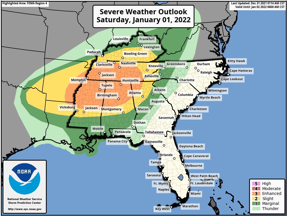
The Storm Prediction Center has increased the risk level for Saturday, New Years Day, to an Enhanced Risk (3 out of 5) for a large area across the South. According to the SPC there will be the risk for damaging winds, large hail, Tornadoes, and even a few long track Tornadoes. If you live anywhere in the outlined areas on the map below, please plan now to take action before Severe weather threatens.
Most storm shelters will open once a Tornado watch has been issued. DO NOT WAIT UNTIL A TORNADO WARNING IS ISSUED TO TRY AND GO TO A SHELTER.
- FEMA guidelines require shelter doors to remain locked during a Tornado warning for that area, so you will not be able to get in.
- You do not need to be driving during a Tornado warning
- Go to a shelter, well in advance of storms reaching your area.
If you are on social media, then you already know all of the drama most of the weather sites push. Just know, there is a risk for Severe weather on Saturday, across a large area of the South. The threat does include TORNADOES and possibly a few STRONG LONG TRACK TORNADOES. This doesn’t mean it will happen everywhere, but it does means conditions are favorable across the entire area for these to occur.
Discussion from The Storm Prediction Center
Widespread thunderstorms are expected from the ArkLaTex to the Western Appalachians on New Year’s Day. All severe-weather hazards are possible including large hail, damaging winds, and tornadoes, a couple of which may be strong.
Most guidance hints at the potential for some warm sector SUPERCELL development across portions of Mississippi, Alabama, and Tennessee Saturday afternoon/evening.
Any strong SUPERCELLS which can develop in the open warm sector will likely have the greatest
threat for significant to potentially intense tornadoes. The most likely region for pre-frontal supercell development will be from eastern Arkansas to northern Alabama and possibly southern Tennessee where greater instability is forecast. Veered low-level flow will keep low-level directional shear limited during the first half of the day. However, at least slightly greater low-level turning is shown by forecast soundings during the late afternoon into the
evening hours as surface flow remains south-southwest, while the low-level jet starts to veer more westerly as the main wave shifts east. This may result in a slightly higher tornado threat into the overnight hours from far eastern Mississippi into northern/central Alabama and northwest Georgia.