
NORTH ALABAMA / CENTRAL ALABAMA — Alabamians are being urged to stay weather-aware as forecasters monitor a developing storm system that could bring hazardous winter conditions to parts of the state later this week.
The National Weather Service (NWS) offices in Huntsville and Birmingham report that a storm system is expected to move across the region Friday and Saturday, January 23–24, 2026. While the system remains several days away and details are still evolving, early signals suggest the potential for winter weather impacts across both North and Central Alabama.
In North Alabama, forecasters say the system is currently expected to track south of the Tennessee Valley, placing the region in a zone where precipitation type could vary significantly. Areas including the Shoals, Sand Mountain, and the Interstate 65 corridor could see anything from cold rain to a wintry mix, depending on small shifts in the storm’s path and the availability of cold air. Meteorologists caution that even slight changes could determine whether North Alabama experiences minor impacts or more disruptive conditions, including light snow or icy roadways.
In Central Alabama, the National Weather Service in Birmingham highlights the potential for a wintry mix, with freezing rain being the primary concern. Ice accumulation poses the greatest threat to travel safety and power infrastructure, especially if frigid air follows closely behind the system. At this time, forecasters say it is too early to identify specific locations or severity levels.
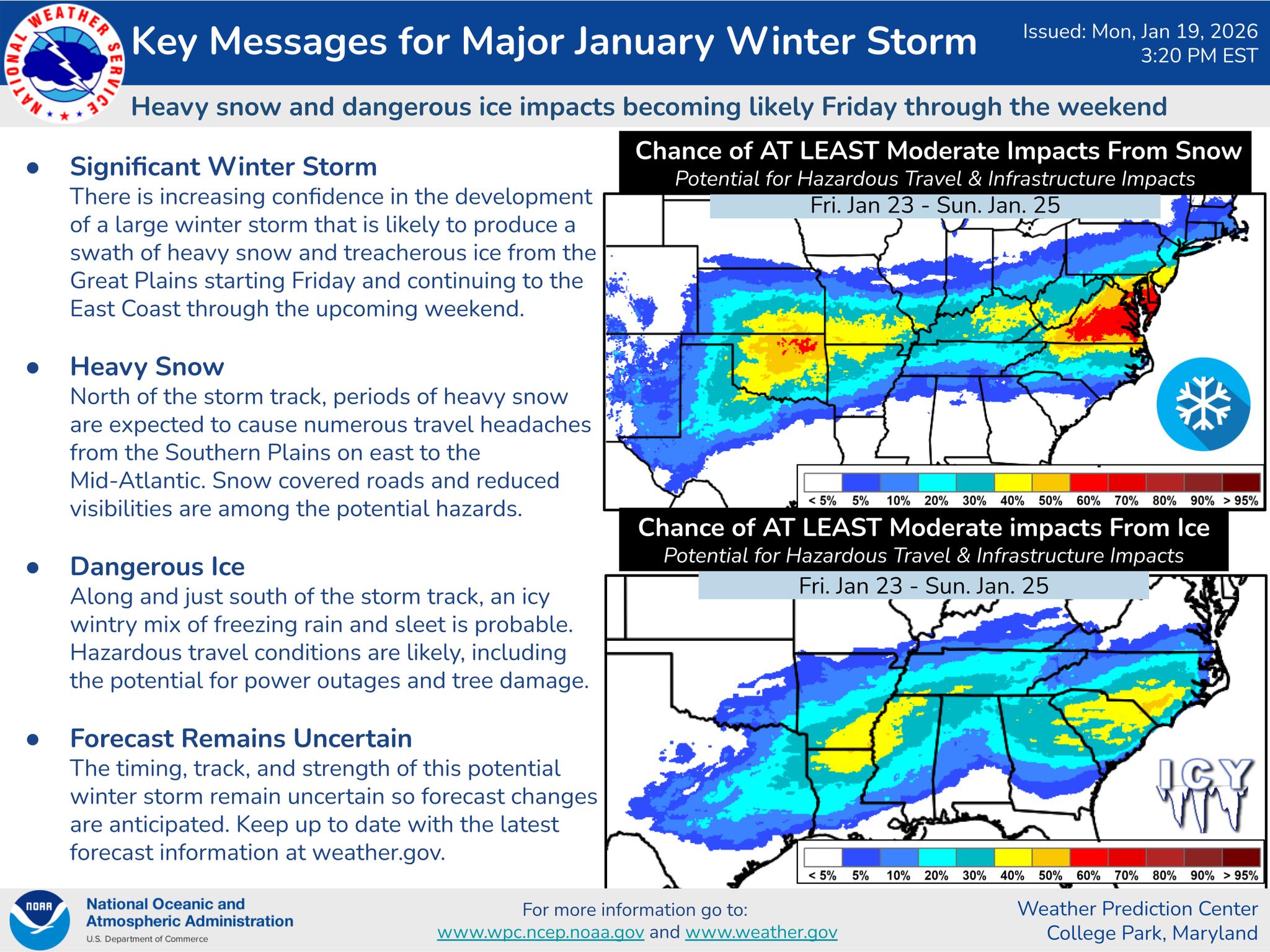
No official winter storm watches or advisories have been issued, and full Area Forecast Discussions from both NWS offices have offered limited detail, underscoring the uncertainty that remains. Broader NOAA outlooks provide little short-term guidance, as seasonal forecasts do not account for individual storm systems.
Despite the uncertainty, forecasters stress the importance of early preparedness.
“We’re not looking at shoveling snow, but rather the potential buildup of ice for parts of Central Alabama,” the NWS Birmingham office stated. “This is the worst kind of wintry precipitation when it comes to travel and power lines. With frigid air pouring in behind the system, that’s a nasty one-two punch should you end up without power.”
Preparation Encouraged Ahead of Potential Impacts
Emergency officials recommend residents across Alabama take precautionary steps now:
Keep at least three days’ worth of non-perishable food, water, and medications.
Have flashlights, battery banks, and extra blankets readily available.
If travel is unavoidable, carry emergency supplies and keep vehicles fully fueled or charged.
Trim weakened tree limbs that could fall on homes or power lines.
Check on elderly neighbors and those who may need assistance.
Use space heaters and generators safely and never heat a home with an oven or stove.
Protect pets and prepare plumbing in exposed or unheated areas.
Charge phones in advance of potential outages.
Use caution on icy surfaces and avoid travel if conditions deteriorate.
Officials emphasize that while the forecast will continue to evolve, taking action now can reduce risks if winter weather develops. Residents are encouraged to monitor updates from the National Weather Service and local emergency management agencies in the days ahead.