
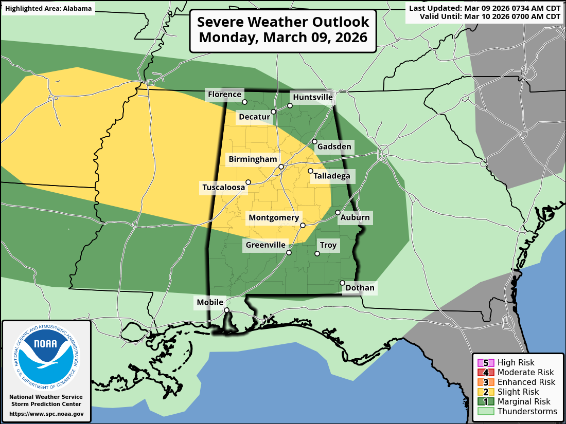
Damaging winds and hail the primary threats this afternoon and evening
Residents across North Alabama should stay alert today as the potential for severe thunderstorms increases during the afternoon and evening hours.
The National Weather Service has placed much of the region under a Slight Risk (Level 2 out of 5) for severe weather as a weather system moves east from Texas and the Mid-South toward the Southeast. Forecasters say warm, moist air already in place across Alabama will help fuel storm development as the system approaches.
According to meteorologists, thunderstorms are expected to organize into a cluster or line of storms as they move east across Mississippi and into North Alabama later today.
Timing for North Alabama
Storms are expected to approach northwest Alabama during the mid-afternoon before spreading across the rest of the region during the evening.
Approximate timing includes:
- Northwest Alabama (Florence, Muscle Shoals, Russellville): 1–5 p.m.
- Huntsville and the Tennessee Valley: 2–6 p.m.
- Northeast Alabama (Scottsboro, Fort Payne, Rainsville): 4–8 p.m.
Storms are expected to move out of the region later in the evening as they track east toward Georgia.
Main Severe Weather Threats
The primary concern with today’s storms will be damaging straight-line winds, which can bring down trees and power lines. Forecasters also say some storms could produce large hail.
While the tornado threat is considered low, it cannot be completely ruled out. A brief tornado could develop within stronger storms along the line.
What Residents Should Do
Emergency officials encourage residents to stay weather-aware throughout the afternoon and evening. Make sure you have multiple ways to receive weather alerts, especially if warnings are issued.
Strong wind gusts can cause localized damage, and heavy rain could reduce visibility for motorists traveling during storms.
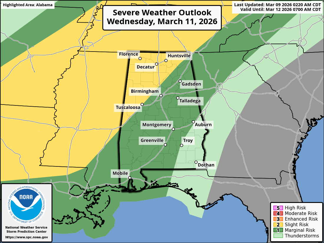
Strong Storms Possible Across North Alabama Wednesday
Residents across North Alabama should stay alert Wednesday as another round of potentially severe weather moves toward the region.
Forecasters say a strong weather system will move across the Southeast during the day Wednesday, bringing the chance for thunderstorms across Alabama. The greatest concern will be across North Alabama, where conditions may become favorable for strong to severe storms.
Warm, moist air is expected to move into the region ahead of the approaching system. As the storm system arrives, that warm air combined with stronger winds in the upper atmosphere could allow thunderstorms to develop and strengthen.
Timing for North Alabama
Storms are expected to develop to the west and move into the area later in the day. Current projections suggest the most likely timeframe for storms in North Alabama will be Wednesday afternoon into Wednesday evening.
Areas across the Tennessee Valley, including Huntsville, Scottsboro, Fort Payne, Rainsville, and surrounding communities, could see storms during this time period.
Main Severe Weather Threats
The primary threats with Wednesday’s storms are expected to be:
- Damaging wind gusts
- Large hail
Forecasters also say there is the possibility of a few isolated tornadoes, although it is too early to know exactly where storms may become strongest.
Staying Prepared
Emergency officials encourage residents to keep a close eye on weather updates as Wednesday approaches. Severe weather can develop quickly, and having multiple ways to receive warnings is important.
Residents should review their severe weather safety plans and be prepared to take shelter if warnings are issued.
Looking Ahead
Forecast details may continue to change as meteorologists get a better picture of how the storm system develops. However, the potential for severe weather means North Alabama residents should remain weather-aware heading into Wednesday. 🌩️